Posts

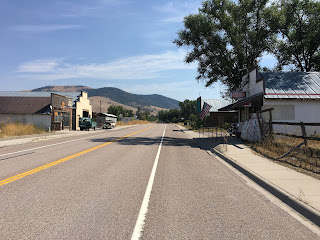
Missoula: Motel to Bike Shop

Image
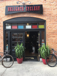
Bike adventure officially complete. Here's the last Strava ride . Last night before bed, I repacked both panniers so that instead of a 50/50 weight split, I had all the bike stuff (kit, tools, parts, etcetera) in one bag, and all the other stuff (street clothes, laptop, toiletries, etcetera) in the other. This morning, I put on street clothes and cleats and knee warmers because it was 45 degrees, then rolled 20 easy minutes from the motel to Hellgate Cyclery. I swapped my cleats for my running shoes, and then I waved goodbye to the bike and one of the panniers. Then I walked half an hour to the Greyhound terminal, and now I'm on a bus headed for Bozeman. Using a bike for long distance transportation is really eye-opening re: just how effective modern vehicles are. My longest day was just shy of 120 miles, and I was completely spent at the end of it. This bus will make that distance in less than two hours, and I'll probably be stiff from sitting still. The plane ride hom

St Regis to Missoula

Image
Bike adventure concludes, more or less. For those keeping track of the actual rides, here's the Strava link . Started the day in St Regis with breakfast (eggs, huckleberry pancakes, coffee), and then sat around willing it to warm up a little bit. By 10:30, it had climbed to 52, so I got on the bike and got going. Massive oversight on my part not taking pictures on Montana 135. That road is gorgeous. And lovely to ride on; decent road surface, not a lot of traffic, and at least a little bit of shoulder for when there are cars. Really, really pleasant. But only 21 miles long, at which point you take a right onto Montana 200. Also gorgeous, but more traffic and less shoulder. I stopped for the first time in Perma, which consists of maybe half a dozen structures you can see from the road, including the Perma Bait Shop, where a super-chatty man sold me a cold coke and then told me I should learn a trade instead of ****in' around with computers, because that's all gonna e

Wallace to St. Regis

Image
That was... unexpectedly hard. Here's the Strava Ride from today, for those keeping score re: how slow I was today. Why so slow? Well, a couple reasons. First, the obvious one: The first third of the ride was uphil. I started in Wallace and headed up the last little bit of the Trail of the Cour d'Alenes into Mullan. FWIW, once the trail hits 90, it's way less awesome; it's basically a frontage road, so it's nice enough, but nowhere near as cool as the part I rode yesterday. There's a fair bit of mining (and mining history) to look at, though, and a bunch of signs that basically say "don't leave the trail, because this vista you're so enamored of is entirely composed of super-toxic mine tailings." Anyway. Got lost for the first time today in Mullan, because the Northern Pacific (NorPac) Trail isn't particularly easy to find. Then, because I took the guy in Kellogg's advice (think like a train; straight and steady), I missed a

Plummer to Wallace

Image
Bike adventure continues! Proof on Strava ! So, turns out that I went a bit over the limit with what will from this day forth be known as the Swamp Hike. Shoving a bike with wheels that wouldn't roll up 12% pitch after 12% pitch through rolling farmland in the rain is super-threshold work, it turns out, and an hour of that after 100 miles on the bike put me in a very bad place physically. Had trouble finding an appetite for dinner, and then slept very poorly to boot; too much caffeine with dinner, maybe, or maybe just trashing my body. The lesson, if there is one? No Swamp Hikes after 330 miles on the bike in 3 days. The upshot to only sleeping about 5 hours last night is that I wound up coming up with a plan, the beginning of which I executed today. First: squirt a bunch of lube on my front hub. Well, --in-- my front hub? But sealed bearing is sealed, so that might have been just a placebo. Second, fart around the motel room trying to work up the nerve to go ride my bike in

Wilbur almost to Plummer

Image
It got interesting. Here's the  Strava ride ; note that it ends in WA before Plummer. That's because that's where I flagged a ride from Nate, the pickup-driving farmer. More on that in a minute. Morning went great. Rode from Wilbur into Creston, where I had breakfast at the Corner Cafe; as good as advertised. Also the waitress had gotten engaged that morning, so all the locals were all aflutter (as was she, obviously). Then back on the bike, which was going great; issues from yesterday seemed solved by the tightened front hub. Lunch in Medical Lake, which was a terrible sandwich. By the time I was back on the bike, it had started to drizzle a little bit. Oh well; riding bikes in the rain is a thing, right? Well, here's the thing. Google Maps isn't great about road surfaces. So, about 20 miles outside Medical Lake, the road I was on abruptly became a 2-mile stretch of farm road. Now, ordinarily, I don't think this would have been such a big deal? But this i

Winthrop to Wilbur

Image
Long, long day. All kinds of fun stuff happened. Let's see. First off, here's the  Strava ride. Added about 15 miles on the "plan," because the "plan" included Google Maps' suggestion to ride over a mountain on Forest Service roads that the locals say are definitely unpaved. So, I had a nice, easy spin down 153 into Pateros, got a snack, and rolled through Brewster to Bridgeport for lunch at the Chief Joseph tavern. Best part about this was the big German Shepherd that decided I looked tasty; dude chased me for a solid 200 meters. That's why Strava claims a max of over 1100W; I did a hard seated acceleration, and that doge just kept coming. So I accelerated more. Felt like sprints with Eddie, for those of you who remember American Flyers. This would have been much more pleasant had the smoke not socked in overnight; there are a couple of decent-sized wildfires burning west of 20/153, and the smoke seems to be flowing straight down the valley to

Rockport WA to Winthrow WA

Image
Woof. Mountains are hard. Strava Post Started the day in Rockport, rolled mostly flat to Diablo, at which point it's just kind of gradually (and occasionally less gradually) uphill for like... 25 miles? I don't know. It was uphill for a long, long time it felt like. Strava claims Rainy Pass is about 18 miles and took me 1:45; seems about right for the first bit. Washington Pass is down and back up again after that, and Strava claims another 30 minutes there; 2:15 up two hills on the day was a LOT. The good news is, from the top of Washington Pass to the Mazama Store (like 20 miles away) is pretty much all downhill. So I coasted there, drank a coke, bought some cookies, and got back on the bike. Got into Winthrop around 6:15, ate a fast snack, showered, and got all ready to roll into town for a burger at the Old Schoolhouse and discovered that I didn't have the key to my bike lock. Or, you know, any keys. Guessing they're in the garage door from when I went